Search results
Create the page "South pole" on this wiki! See also the search results found.
Page title matches
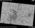
File:South Pole Terrain.jpg South Pole Terrain, as seen by hirise. Location is 87.6 S and 1.4 E. Terrain is calle(800 × 659 (135 KB)) - 10:51, 3 April 2018

Page text matches
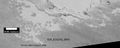
File:ESP 014274 0955southpole3.jpg South pole swiss chees terrain, picture taken August, 2009.(1,390 × 558 (273 KB)) - 16:15, 5 January 2020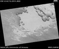
File:ESP 014274 0955southpole.jpg South pole swiss chees terrain, picture taken August, 2009.(2,048 × 1,711 (851 KB)) - 16:13, 5 January 2020
File:Spiders2eruptionlabeled2.jpg Drawing showing how spiders/plumes happen near the south pole of Mars each Martian spring.(1,072 × 840 (48 KB)) - 15:51, 29 September 2022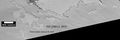
File:ESP 058515 0955southpole2.jpg South pole swiss chees terrain, picture taken January 19, 2019.(1,654 × 550 (200 KB)) - 16:17, 5 January 2020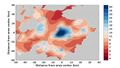
File:Lakessouthpole.jpeg Radar data showing possible lakes under south pole ice cap.(650 × 366 (52 KB)) - 10:34, 30 September 2020File:South Pole Terrain.jpg South Pole Terrain, as seen by hirise. Location is 87.6 S and 1.4 E. Terrain is calle(800 × 659 (135 KB)) - 10:51, 3 April 2018
File:Wikimolasouthpole.jpg MOLA map showing boundaries around south pole of Mars(800 × 355 (36 KB)) - 07:43, 28 March 2018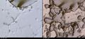
File:ESP 058515 0955closechanges.jpg Changes in a small part of swiss cheese surface in South Pole region. Picture on left taken in August 2009--Picture on the right taken i(2,660 × 1,210 (1.65 MB)) - 16:23, 5 January 2020


